


With a spirit of urgency, seriousness, and high responsibility, the campaign is being executed synchronously across the province, aiming to build a unified, accurate, and transparent land database to effectively serve state management and ensure the rights of citizens and businesses.
On September 19, 2025, the Provincial People’s Committee issued Plan No. 4997/KH-UBND and established a Provincial Steering Committee to implement the land data cleaning campaign from September 1 to November 30, 2025. The plan’s objective is to enrich and clean the land database to ensure completeness, synchronization, uniformity, accuracy, and timeliness (“correct - sufficient - clean - live - unified - shared”), serving state management on land, improving the quality of public service delivery for citizens and businesses; and meeting the requirements for sharing and connecting land data with the national database and other specialized databases.
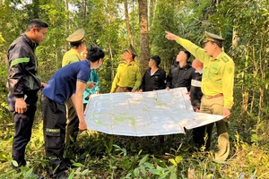
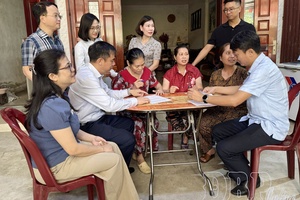
With the motto “go to every alley, knock on every door, review every land plot,” localities within the province have mobilized the involvement of the entire political system, with the core forces being the police, cadastral officers, judicial officers, and youth union members. Localities established mobile working groups to go directly to each household to propagate, guide declarations, collect, and cross-check information on Certificates of Land Use Rights, Ownership of House and Other Assets Attached to Land.
.jpg)
To facilitate the review process, the Department of Agriculture and Environment requested the Vietnam Map - Informatics Joint Stock Company - the unit deploying the VBDLIS land information system software (Vietnam Land Information System) in Điện Biên province - to support the provision of tools and techniques to convert the land database from a 3-level to a 2-level local government model, contributing to shortening the process of updating and sharing information.
Pú Nhung is the first commune in the province to complete the land data cleaning campaign. The commune was assigned to review 236 Certificates of Land Use Rights, Ownership of House and Other Assets Attached to Land. The Commune Steering Committee organized meetings to devise a specific plan. Through determination, effort, innovative initiatives, creative methods, and a high sense of responsibility, the 90-day land data cleaning campaign in Pú Nhung commune took only 54 days to complete (completed on October 23), finishing 36 days ahead of schedule and becoming the leading unit in the province.
Nguyễn Văn Bách, Chairman of the People’s Committee of Pú Nhung commune, stated: To achieve the set goals, the process of cleaning land data was identified not only as a technical task but also as a foundation for building a digital government to serve the people better. When data is standardized, the handling of administrative procedures will be fast, transparent, and will reduce errors and disputes. notably, the Commune Steering Committee organized meetings to assign specific tasks according to the motto “clear person, clear task, clear time, clear responsibility, clear product, clear authority.” This was considered a guiding principle throughout the direction and administration to implement tasks synchronously and uniformly. At the same time, the entire political system was mobilized to get involved.
As of November 5, Điện Biên province has transferred 186,735 land data points to the National Population Data Center under the Ministry of Public Security for cross-checking, ensuring consistency and accuracy between land information and population information. The entire province currently has a total of 63,887 Land Use Rights Certificates needing collection from the commune level. Localities have collected 37,556 certificates, reaching 61.64%. Regarding data entry, the entire province has had 4,199 Land Use Rights Certificates handed over by communes to the Land Registration Office Branch for entry into the system. To date, 9,362 data points have been entered into the VBDLIS software, reaching 73.7%.
However, many localities faced difficulties during the land data cleaning process. Some communes have low collection rates, such as Mường Luân reaching 48.73%; Na Son reaching 20.43%; Xa Dung 15.21%, and Nà Tấu only reaching 10% (as of November 5). The main reasons are that archived records have not been scientifically arranged, many certificates issued long ago have been lost or damaged, and updates on land user information are slow. Additionally, a segment of the population has not cooperated in providing information due to hesitation or a lack of understanding regarding the significance of “cleaning” land data.
Implementing the 90-day campaign to build and perfect the land database, by October 24, Điện Biên Phủ ward had organized the collection of 7,400/11,451 dossiers, including Land Use Rights Certificates and citizen identification cards of land users. 3,215 dossiers were entered; 2,493 dossiers were scanned; and 988 dossiers and complete forms were handed over to the Land Registration Office Branch Area 1.
During implementation, Điện Biên Phủ ward encountered many obstacles: The quantity of issued Land Use Rights Certificates is very large, and through many periods of splitting and merging departments, divisions, and units, archive management has not been tight, unified, or synchronous, making review and lookup difficult. In the areas of old wards, there are still many land plots that, although having owners, are currently vacant and have been transferred through multiple users, so the streets and wards have not updated timely, leading to the inability to identify the current land user.
To complete the targets by the end of November, on November 10, the Provincial People’s Committee launched an emulation movement for “enriching and cleaning the national land database.” The content of the emulation focuses on 4 main tasks including: Emulation to perfect the existing land database, ensuring “correct - sufficient - clean - live”; building residential land and housing data for places that have not yet built a land database; completing the synchronous connection and sharing of a unified, shared land database; and emulation in the management and operation of the land database and online public services. Each cleaned data point, each accurately updated certificate is a solid step forward on the path of building a “rich” and “clean” land data foundation, serving the people, businesses, and the province’s development better.
Quốc Huy
.jpg)

.jpg)
.jpg)
.jpg)
.jpg)
.jpg)
.jpg)
.jpg)
.jpg)
.jpg)
.jpg)
.jpg)
You have 500/500 characters left
Please enter 5 or more characters!!!