



This shortfall impacts the effectiveness of state administration, administrative procedure processing for citizens and businesses, and local investment attraction. Consequently, Điện Biên province is mobilizing the entire political system to expedite the review, standardization, and completion of data under the criteria of “accurate, adequate, clean, and live.”
.jpg)
Implementing Prime Minister’s Directive No.05/CT-TTg dated February 13, 2026, and Joint Plan No.2959/KH-BNNMT-BCA dated March 29, 2026, issued by the Ministry of Agriculture and Environment and the Ministry of Public Security, the People’s Committee of Điện Biên province promulgated Plan No.3870/KH-UBND on May 15, 2026, on surveying, cadastral mapping, cadastral record establishment, and land database construction across the province. The core requirement is that finalized data must meet the “accurate, adequate, clean, and live” standard, ensuring direct connectivity with the national population database.
According to a report by the Department of Agriculture and Environment, the province has 1,684,196 land parcels requiring surveying and cadastral record creation, of which 818,616 parcels - corresponding to 656,318.64 hectares - have been surveyed. Currently, 865,580 land parcels spanning 204,606.5 hectares across 44 out of 45 communes and wards remain to be surveyed and mapped cadastrally.
.jpg)
Lê Xuân Cảnh, Director of the Department of Agriculture and Environment, stated: “Completing the land database is a crucial task that goes beyond digitizing records; it requires building data that is accurate, adequate, clean, live, unified, and shared, capable of being updated, interconnected, and utilized effectively, thereby unlocking land resources and contributing to growth. The province prioritizes cleaning existing data while establishing workflows to promptly update all land fluctuations, such as transfers, donations, inheritances, mortgages, parcel subdivisions, and land use purpose conversions. As data is completed, it is immediately integrated into management, operation, and exploitation.”
To execute the task, the provincial People’s Committee organized a conference to standardize procedures for surveying, cadastral mapping, record compilation, and land database development under Circular No.19/2026/TT-BNNMT. Steps are conducted synchronously by map sheet, locality, and phase, with clear delineation of responsibilities among specialized agencies, commune-level authorities, land registration offices, contractors, supervisors, and land users. Despite difficulties, Điện Biên province has identified three focal task groups: continuing to enrich and clean data for 25,609 land parcels; building the land database for 675,678 parcels; and surveying and establishing a new database for 865,580 parcels.
At this stage, land registration office branches across the province are concentrating on reviewing, supplementing spatial data, scanning files, and updating missing parcel information in accordance with instructions.
.jpg)
Dương Thị Minh Dịu, Director of the Land Registration Office (Department of Agriculture and Environment), stated: “We have assigned clear personnel, clear duties, and clear timelines, focusing workforce resources on localities and file groups with lingering backlogs, while conducting regular inspections to untie bottlenecks promptly. Currently, the land registration office is concentrating on re-editing maps for 45 communes and wards and constructing the land database. Based on these outcomes, communes and wards conduct reviews, supplement data, and guide residents in declaration and registration.”
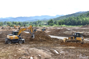
For commune-level People’s Committees, the province outlined two key task groups in cadastral surveying, land registration, cadastral file creation, and database development. For areas already surveyed and mapped but not yet granted land use right certificates, commune authorities review the current status, files, and maps; guide land registration declarations; notify registration results; and issue certificates within their jurisdiction. For unsurveyed zones, commune levels coordinate cadastral surveying, file establishment, and database development simultaneously with surveying work.
.jpg)
Tuần Giáo commune has 15,281 land parcels requiring database construction, including 12,350 parcels of macadamia, rubber, and forestry land, and 2,931 parcels requiring cadastral surveying. Quàng Văn Cương, Chairman of the People’s Committee of Tuần Giáo commune, shared: “Implementing the provincial plan, Tuần Giáo commune established a Steering Committee and assisting teams, assigning tasks according to the ‘six clears’ principle while assigning cadres to review surveying workloads, mapping, and cadastral records. The commune stepped up communication across all 28 villages, mobilizing citizens, organizations, and businesses to coordinate in boundary demarcation and provide records and information to clean and enrich land data. Facing a massive workload and tight timelines, the commune mobilized maximum manpower and tightened coordination with the commune police and the Land Registration Office Branch to resolve hurdles and guarantee progress.”
Completing the land database not only lays a foundation for digital transformation, but also provides a vital instrument to elevate state land management toward transparency and modernization. Concurrently, it enhances public service delivery quality, reforming and streamlining land-related administrative procedures for citizens and enterprises. With a systematic roadmap, decisive execution, and synchronized involvement from all levels, sectors, and localities, Điện Biên aims to complete its land database on schedule, creating momentum for sustainable socioeconomic development.
Nhật Phương

.jpg)
.jpg)

.jpg)
.jpg)
.jpg)


.jpg)
.jpg)


.jpg)

You have 500/500 characters left
Please enter 5 or more characters!!!