
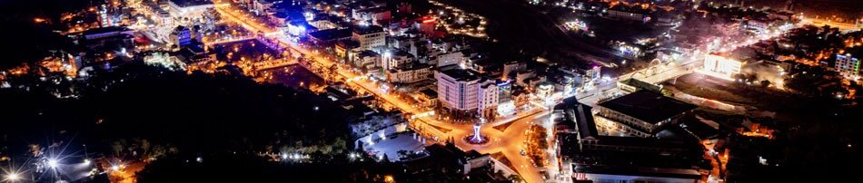
From a mountainous border province facing numerous challenges and possessing only a small scale urban network, Điện Biên is gradually shaping a new urban landscape that is synchronized, green, and modern while still preserving the cultural identity of the Northwest region. This is not only a requirement of industrialization and modernization but also a driving force for economic growth and improved living standards. Shortly after the Politburo issued Resolution No. 06-NQ/TW, Điện Biên swiftly translated it into practical plans and tasks aimed at synchronizing urban planning, construction investment, and urban management.
Currently, the province has three wards: Điện Biên Phủ, Mường Thanh, and Mường Lay, along with several officially recognized urban areas such as Tuần Giáo, Mường Ảng, Tủa Chùa, and Mường Chà. Among them, the inter-ward urban area of Điện Biên Phủ - Mường Thanh is continuing to complete criteria for a Class-II urban area, while Mường Lay is striving to achieve Class-III urban status. Approximately 96.6% of existing urban areas already have master plans, zoning plans, urban renovation and redevelopment programs, and urban development plans. The province’s urbanization rate has reached 25.8%; average urban green space stands at 12.93 square meters per person; and transport land accounts for over 20% of urban construction land.
Alongside planning efforts, investment in urban infrastructure has been identified as a breakthrough priority. Numerous key projects have been completed and put into operation, significantly transforming the province’s urban appearance. In the Điện Biên Phủ – Mường Thanh urban area, major projects include Điện Biên Airport, Thanh Bình Bridge, the 60-meter boulevard, urban backbone infrastructure systems, Nam Thanh residential area, Hoàng Văn Thái - Khe Chít urban area, and Him Lam resettlement zone. Beyond the central urban area, Điện Biên is also focusing on infrastructure development in highland regions, resettlement zones, and commune centers.
.jpg)
Despite these achievements, the urbanization rate remains modest at 25.8%. Several targets related to housing, digital infrastructure, and planning have yet to meet expectations. Cultural facilities, parks, and public recreational spaces remain insufficient. Investment resources still rely heavily on the central government budget, while infrastructure demands continue to rise. In addition, the province’s mountainous terrain and scattered population make synchronized infrastructure development particularly challenging.
According to the Department of Construction, the 2026-2030 period has been identified as a phase of urban spatial restructuring toward a more synchronized, modern, green, and smart model built upon science, technology, and digital transformation. By 2030, the province aims to raise the urbanization rate to 32%; ensure transport land accounts for at least 20% of urban construction land; increase urban construction land to approximately 1.9-2.3% of total natural land area; maintain average urban green space at around 10 square meters per person; and raise average urban housing floor space to 28 square meters per capita.
Special attention is being given to renewing urban planning thinking in connection with socio-economic development strategies while ensuring connectivity between urban and rural areas as well as among urban centers themselves. The province is currently focusing on completing general planning systems for 41 out of 45 communes and wards within 2026, while simultaneously reviewing and adjusting zoning and detailed plans to align with the new administrative model. The application of digital technology, GIS systems, and digital databases in planning and urban management will also be accelerated to improve transparency and feasibility.
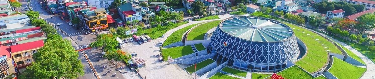
At the same time, Điện Biên is developing its urban system along the strategic Sơn La – Điện Biên - Tây Trang Border Gate expressway corridor. This route is considered the “backbone” for establishing a regional urban network that can promote trade, logistics, tourism, and services. Beyond simply expanding urban space, Điện Biên is also moving toward green and smart urban development. During the 2025-2040 period, the province plans to build a pilot residential area featuring eco-friendly drainage systems, solar-powered lighting, and non-fired construction materials; renovate an inner-city park into a “model ecological park” with regulating lakes and eco-walking paths; and plant 10,000 native urban trees.
The development of smart urban areas, particularly the Điện Biên Phủ - Mường Thanh urban zone, places residents at the center while using data and digital infrastructure as the foundation of governance. Nguyễn Quang Hưng, Secretary of the Điện Biên Phủ ward Party Committee, stated that the ward is gradually advancing digital infrastructure development and applying artificial intelligence in governance, administration, and public services.
Efforts such as improving digital capacity for officials, maintaining effective community Zalo groups, and synchronously undergrounding electricity and telecommunications systems in new urban areas have laid the groundwork for a modern and civilized urban landscape. In particular, cooperation with IGB Group to develop smart tourism maps, AI chatbots, digital libraries, smart agriculture, and e-commerce platforms is opening up important opportunities for Điện Biên Phủ ward to move toward a green, modern, and intelligent urban model.
Sustainable urban development based on science, technology, and digital transformation is not only an immediate requirement but also a long term strategic direction for Điện Biên in the process of integration and development. With strong political determination, public consensus, and sound development orientation, Điện Biên is gradually building a system of green, modern, smart, and culturally distinctive urban areas that will create new momentum for socio-economic development and improve the quality of life for local residents.
Quốc Huy
.jpg)
.jpg)
.jpg)
.jpg)
.jpg)
.jpg)
.jpg)
.jpg)
.jpg)
.jpg)
.jpg)
.jpg)
.jpg)
You have 500/500 characters left
Please enter 5 or more characters!!!